

Phantom 4 RTK Full Workflow
How to effectively use the
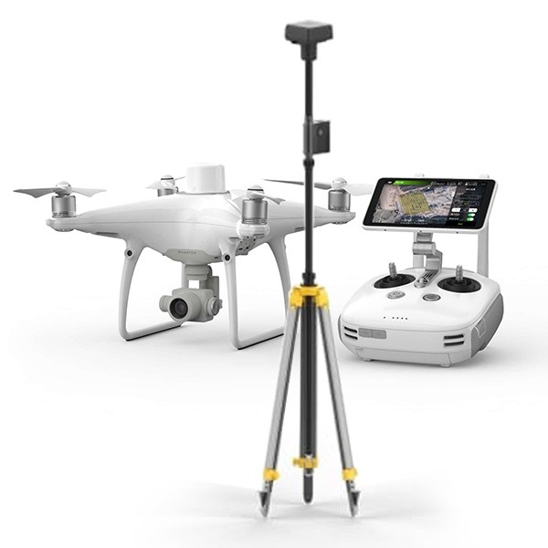
D-RTK 2 High Precision GNSS Base Station
The purpose of this guide is to create the most reliable, accurate, and efficient workflow to enable land surveyors and civil engineers to collect and process data with the DJI Phantom 4 RTK and the DJI D-RTK-2 base station.

Aerotas has been successfully processing data collected with the Phantom 4 RTK since October of 2018. But, until now we have been unable to get reliable survey grade results from this system when using the DJI D-RTK 2 Mobile Station that comes with the Phantom 4 RTK. We have been recommending the PPK processing workflow and utilizing 3rd party base stations from providers like Trimble or Leica.
Aerotas is pleased to report that this workflow will make the D-RTK 2 Mobile Station a valuable tool that delivers accurate and reliable results.
Workflow Summary
Set and measure a single ground control point
Setup the D-RTK-2 base station & aircraft
Fly the project site as normal
Process a full resolution sparse point cloud
Adjust the sparse point cloud to align with GCPs
Process the full-resolution outputs
When deployed properly, the D-RTK-2 base station paired with the Phantom 4 RTK is capable of calculating image geolocation with high precision, but low accuracy.
Aerotas has developed a combined field/office workflow that enables surveyors to lock the relative accuracies in photogrammetry processing, and shift the entire project to match a single ground control point.
This allows surveyors to ensure full-site accuracy without the need for manual PPK processing, or ground control distributed throughout the entire project site.
Data Collection Workflow
Mission Planning
Set & Measure Ground Control / Checkpoints
Turn on / setup drone equipment
Fly Site
Considerations for large multi-battery missions
Office Processing Workflow
Process Sparse Point Cloud
Adjust to align with GCPs
Run quality assurance checks
Process full-resolution outputs
Draft Linework, and Integrate into CAD
FAQ
What has changed between when the P4RTK launched and this method?
The hardware and software produced by DJI as part of the Phantom 4 RTK and D-RTK-2 base station is essentially unchanged from when it was initially launched. However, our testing has shown this to be a more reliable workflow than any that we have previously published.
Can I still do PPK processing?
Yes, collecting data with this method does not prevent you in any way from PPK processing your data as well. In fact, that is part of what makes this a more reliable workflow, as it can potentially “fall-back” to PPK processing mode should there be any issues with the in-flight RTK processing.
Can I use network corrections (NTRIP via 4G dongle)?
While it is possible to use the DJI 4G dongle attachment to stream network corrections to the Phantom 4 RTK, we do not recommend this workflow, because we have found it to be too complex and unreliable in the field. Adding numerous sources of cellular connectivity and account logins creates numerous possible failure modes, resulting in a less reliable workflow. If however, you are already successfully using a workflow with 4G network corrections, feel free to continue doing so, as you can still post-process using this workflow.
Why do I still need ground control points?
DJI’s base station does not calculate the correct ground point when used multiple times and occupying the same point. Further, even when occupying a “known point” with the DJI base station, the poor construction of the tripod, and lack of support for datums other than WGS84 render this workflow inoperable for most surveyors. Further, if there is a known point on the ground, it is simpler to just mark it and use it as a GCP in this workflow than introduce another possible source of error to the overall project.
Do I still need checkpoints?
Checkpoints are highly recommended, even though they are not strictly required by this workflow.
How can I ensure that a project processed accurately?
Utilizing independent checkpoints is the only way to reliably measure accuracy on a project produced with this workflow. This methodology is endorsed by the American Society for Photogrammetry and Remote Sensing (ASPRS) and is laid out in the Positional Accuracy for Geospatial Data standards document.
Do I need to use Aerotas to process my data?
Aerotas provides the highest quality data processing services, performed by trained and experienced photogrammetry professionals. However, there is nothing in this workflow that is proprietary to Aerotas, and experienced photogrammetrists should be able to follow this workflow.
How reliable is this workflow?
This workflow is designed to be as robust and reliable as possible through the most challenging of real-world scenarios. It does not require a live internet connection of any type while at the job site, and has minimal reliance on radio signals that may be interrupted during the flight. The only important radio link that must be maintained is that between the controller and the aircraft, as that is how RTK correction data is streamed and processed so it can be encoded onto the photos.
Can I get support for this workflow?
Aerotas provides support for this workflow free of charge to all of our data processing clients, however we cannot offer free support on this workflow to the general public. To work with Aerotas, contact us at info@aerotas.com, or sign in to start a new project for free, and receive a no obligation quote. Quotes are free. No credit card needed.