
Flying in Controlled Airspace
Over 98% of the land in the United States does not require any authorization to fly a drone up to 400’ above ground level; however, there are still major portions of US cities that are in controlled airspace.
Thankfully, over the past few years, the FAA has considerably loosened their airspace restrictions, while also making it much easier and faster to get one-off airspace authorizations for project sites near, or even on airports themselves.
Of the 15,000 airports in the US, fewer than 900 are in controlled airspace that requires authorization. Moreover, of those, 600 airports participate in the FAA’s LAANC program. LAANC is the Low Altitude Authorization and Notification Capability; it provides access to controlled airspace near airports through near real-time processing of airspace authorizations below approved altitudes in controlled airspace. Non-participating airports can still grant authorization through a manual filing if needed.
So in almost all cases, the answer is “yes” it’s legal to fly there, and it is much easier to get approval than it was even one year ago.
What is an airspace authorization?
An airspace authorization, is asking permission to fly in controlled airspace in adherence to all part 107 rules and specific altitude parameters. This is NOT the same as a waiver, waivers are explained here.
How do I know if I need an to submit an airspace authorization request?
The FAA’s “Visualize it: See FAA UAS Data on a Map” website, provides a visual representation of all the areas you need to obtain authorization in before flying. A screen shot of this website is provided below.
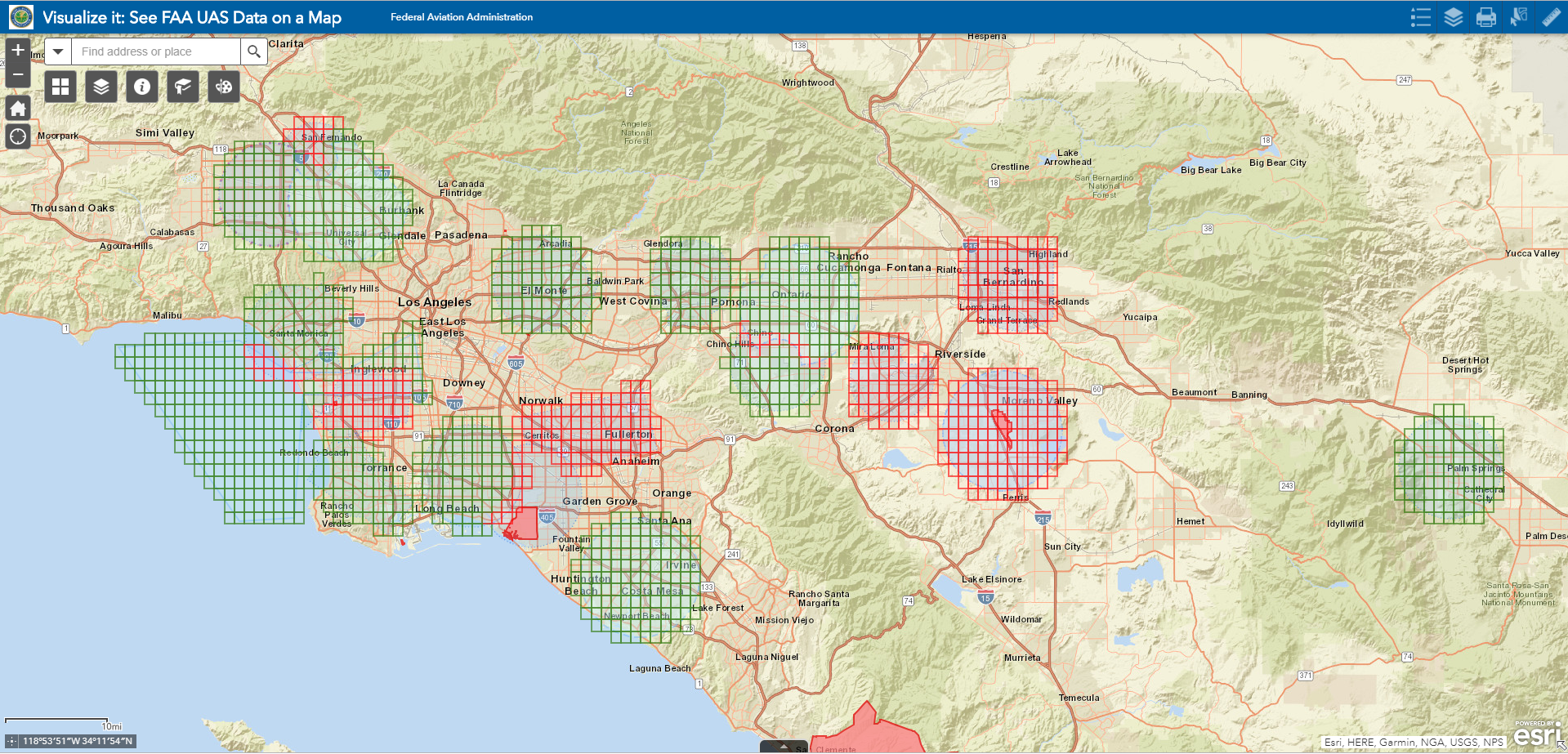
The red and green grids in the picture above, represent all areas that you need to obtain authorization in before flying.
How do I use the information on the “Visualize it” website?
The green grids represent airports that are LAANC enabled (Low Altitude Authorization Notification Capability), meaning you can get instant real time authorization to fly in these zones through approved apps such as Airmap, and not have to file a formal request through the FAA website and wait for their response. The red grids are airports where you are still required to submit a manual authorization request through the FAA website and are NOT LAANC enabled.
If we zoom in on the previous image (below) you will notice numbers on each grid block. These numbers represent the ceiling altitude at which you can obtain an authorization to fly up to. This does NOT mean that you can fly up to these altitudes without permission. You can request higher altitudes than posted, up to 400’, however these higher-than-posted requests are less likely to be approved.
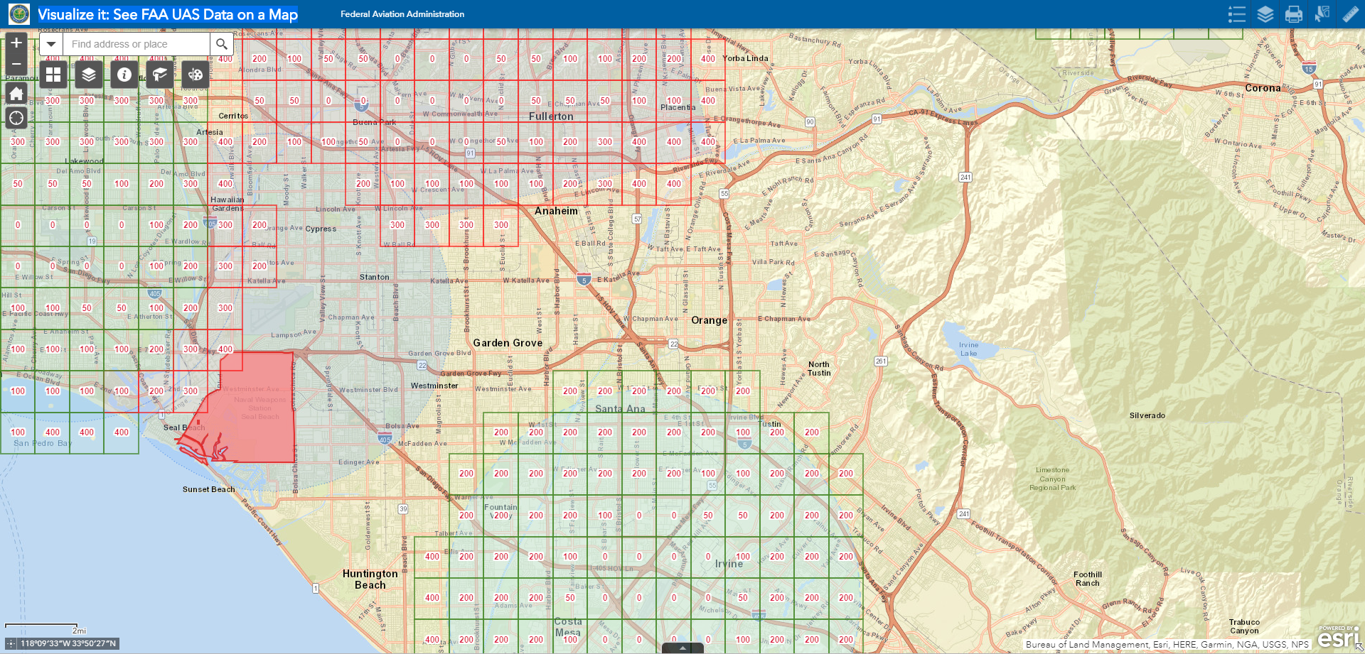
If you click on a specific grid block, it will give you almost all of the information you would need to file a general airspace authorization for that area.

Some areas are restricted areas such as this Naval base (above). Here you need special permission from the base itself to fly in the area in red. If you click on the red area, contact information is given for the specific base. If calling a controlling agency, be sure to know all parameters of your flight, including address, height, duration, and specific date and time of day you plan on operating.
How do i file a manual airspace authorization request?
If you are a commercial UAV operator, you should already have an account at https://faadronezone.faa.gov/#/ where you registered your UAV. Log in to this account.
Once you are in, you will want to click on "Dashboard" next to "Fly sUAS under part 107".
Next, locate the button for “Create Part 107 Waiver/Authorization”.
Next you will be prompted to select what you are applying for. Below are the 3 options, you will want to click the second option, as we are applying for an authorization and not a waiver.

After you select airspace authorization you will start the application. Below is an example of the information you will need to apply for the authorization. Make sure the parameters fit your needs and be sure that each field is in adherence to part 107 regulations (flying during daylight hours only and not requesting more than a 400’ altitude). If any part of this request is not in adherence to part 107, it will be denied as an incorrect form submission. Generally, you should not need to break any part 107 rules for aerial mapping purposes. Next we will walk through each field in the authorization request.

This specific authorization request was for a 6 month time period but ended up getting approved for the better part of a year, choose a reasonable amount of time for your request. A lot of times, you will get approved for longer periods than you requested on benign requests, simply to reduce the amount of times you need to submit the request.
The time frame is next, they give you 4 options. Select the 3 options that remain within the parameters of part 107, and keep us from having to file for a waiver (sunrise to sunset, as we are not doing drone surveying at night, which would require a waiver because it breaks a part 107 rule).
Moving on is the “frequency of flight”. This field is to generally estimate how often you will be flying. Depending on the nature of your site/mission, select the closest possible option to your needs.
After this, we are filling in the time zone, and the proposed max flight altitude. As you can see, I have applied for 400' AGL. This is the maximum altitude and keeps us within parameters for part 107 rules. (If you are applying for a grid block with a lower altitude, requesting above the altitude listed will decrease your chances of approval)
The next text box asks for proposed location of operations. The description I provided both explains the area that was applied for, and ensures that we will be following the altitude restrictions published on their website.
Below that, is a coordinate that it asks for, the coordinate you should enter can be taken from the “Visualize it” website when you click the specific grid block you are operating in, or you can obtain an exact location by using the “ruler” icon in the top right page of the FAA Visualize it site (shown below), click the measurement icon ad change the units to “DMS”, and click to add your point at the center of your site.

Next is the radius, we applied for a "blanket area/wide area" on the example authorization. This wide area will cover all airspace in that specific grid. If you know you will have projects elsewhere in the airspace, this is not a bad option to consider. Otherwise, be as specific as you can.
To measure radius, click the ruler in the upper right corner of the FAA Visualize it site, then select the “distance” icon, click your project center, and drag the line out from there to the boundary of your site (shown below). Always round up when requesting for a specific radius, for example, if your site radius is .12 miles, round up and request for a 1/4 mile radius.

Next is the nearest airport. This will be the airport you are applying for authorization through, the 4 letter airport identifier can be found by clicking the grid block you are trying to fly in, on the “Visualize it” Site.
Next you'll select the class of airspace.
The last part of this application is arguably the most important. It is the description of the operation. The response I put in is a response that has been tried and true for our clients when applying for airspace auths; it describes what we are doing specifically, and what rules we are going to follow. It also shows our knowledge of the drone system and covers all of our bases as far as emergency procedures and ensures that we know what we are doing and have our part 107 licenses to operate. Feel free to use this description on your authorizations, just be sure you are familiar with all of the verbiage.
After that, simply click submit and wait for a response to come to your email, usually within 3-10 business days from our experience.
After you have received a response, log back in to your FAA drone zone account and view the authorization documentation attached to your authorization, this will give you specifics of your authorization and include any special instructions deemed necessary by the controlling agency who approved your request.