How to Get the Most Out of Aerial Lidar Data
Lidar technology has been around for decades, and significant technological advancements have now made lidar more accurate, reliable, and affordable than ever before. At Aerotas, we've been processing aerial lidar data for years, and we've observed that lidar technology has recently reached a maturity level where it's no longer exclusively the domain of early adopters. Although the cost of producing lidar data has dramatically decreased, integrating aerial lidar into surveying operations still requires considerable expertise to be done effectively. We are publishing this blog post to share our knowledge with the broader Land Surveying community, and to highlight the growing opportunities lidar technology offers to surveyors and mapping professionals. Aerotas brings together the necessary expertise and technologies to ensure surveying organizations not only leverage lidar effectively today but also drive innovation into the future.
A Brief History of Aerial Lidar Technology
Lidar has a surprisingly long history, dating back to the 1960s with the creation of the first lidar systems. However, practical aerial lidar applications didn’t emerge until the 1990s, enabled by advancements in GPS and laser scanning technology. Even then, systems remained prohibitively expensive, often exceeding a million dollars.
The early 2000s saw lidar’s capabilities showcased dramatically through archaeological discoveries of ancient Mayan cities hidden beneath dense jungle canopies. This captured public attention and demonstrated lidar’s remarkable mapping capabilities.
Drone-based lidar first appeared in the mid-2010s, though cost barriers still prevented widespread adoption among surveyors. Even basic systems could cost hundreds of thousands of dollars. The turning point came in 2020 with DJI’s release of the L1 sensor. While not the most powerful sensor available, its price under $50,000 made it practical for a broader range of survey applications, igniting competitive pricing throughout the industry.
In late 2023, DJI's introduction of the L2 further improved performance significantly at a similar price point, pushing other providers to enhance their offerings. Today, aerial lidar mapping is mainstream and more accessible than ever.
Understanding Lidar Technology
LiDAR, or Light Detection and Ranging, operates by emitting rapid laser pulses from an aircraft toward the earth, measuring the time it takes for these pulses to reflect back to the sensor. Each pulse can generate multiple returns as it interacts with various surfaces, such as treetops, vegetation, and the terrain below. This method allows lidar to map detailed topographic data, even through dense vegetation, by detecting gaps in the foliage.
The sensor captures both the timing and intensity of each reflected pulse. Specialized software processes these returns into precise measurements of distance and elevation, creating a high-density point cloud composed of millions of data points. The resulting detailed 3D models make lidar invaluable for accurate topographic mapping, engineering, and infrastructure development.
The Challenges of Processing Lidar Data
While capturing lidar data has become straightforward with technological advancements, gathering the correct data and processing it effectively remains significantly challenging. Many surveyors initially underestimate the complexity of the full process, assuming the hardest part is data collection. In reality, the true challenge—and the area with the greatest potential risk—is accurately processing the massive volumes of data collected. Processing lidar data involves numerous highly specialized steps, each demanding distinct skills, sophisticated software tools, and deep industry expertise. Attempting to handle these steps in-house often results in considerable strain on resources and significant hidden costs, detracting from the primary business of surveying and mapping. The time and expense required to train personnel, license software, and maintain quality control can quickly diminish the return on investment. Mistakes in processing accuracy can lead to costly field revisits, delayed project timelines, and loss of client trust. It's precisely because of these complexities and potential pitfalls that many organizations find greater value and efficiency by partnering with expert lidar processing teams.
Processing lidar data involves multiple specialized steps, each requiring distinct skills, software tools, and deep knowledge. Below is a list of the core capabilities required to successfully process aerial lidar data for surveying.
Mission Planning
Planning missions to collect quality data involves setting up precise GPS configurations, determining optimal placement for ground control or check shots, and ensuring ideal flight conditions.
GNSS Processing
Accurate GNSS data processing is crucial for generating high-quality point clouds. This complex process varies with hardware and field setups, project coordinate systems, and specific survey goals. Aerotas provides detailed webinars on GNSS processing for those interested in diving deeper into this critical stage.
Lidar Modeling
Creating the initial lidar point cloud is relatively straightforward and software-driven, yet ensuring proper georeferencing and alignment can be intricate depending on field conditions.
Accuracy Verification
This critical yet often overlooked step involves verifying the accuracy of the generated point cloud. Adhering to ASPRS positional accuracy standards—considered the gold standard—is vital for measuring or certifying accuracy.
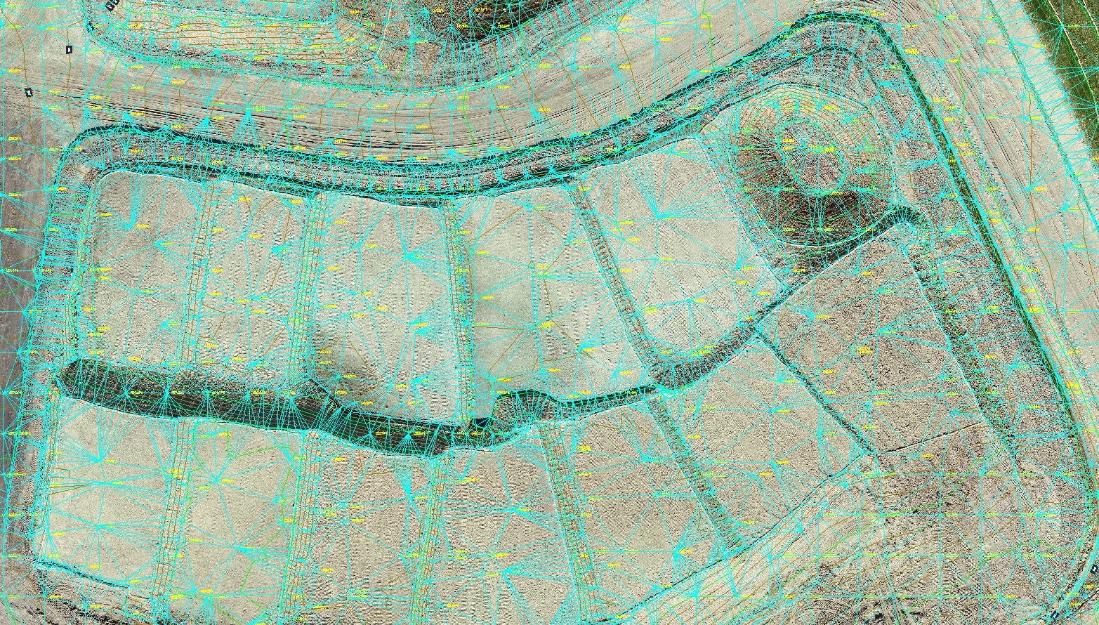
Point Cloud Classification
Post-verification, points within the cloud must be classified into relevant categories (ground, trees, buildings). This step combines automated algorithms and significant manual effort. Accurate classification requires expert judgment, especially when distinguishing complex features such as low grass and minor terrain variations.
Topographic Modeling
Creating an effective topographic surface from classified data necessitates additional processing. Typically, this involves rasterizing ground points into a Digital Elevation Model (DEM) and then developing a Triangulated Irregular Network (TIN) surface through topo points and breaklines, ultimately exported into CAD formats.
Linework Drafting
Drafting detailed linework—such as roads, utilities, buildings, and pavement markings—is highly time-intensive. Because automated software is still unreliable for this precision work, combining lidar point clouds with photogrammetry-derived orthophotos often yields the best results.
Advanced Feature Extraction
Some complex features, such as powerlines, poles, and curb lines, cannot be directly extracted from point clouds and must be modeled meticulously in 3D before digitization. This demands exceptional skill and attention to detail.
Final CAD Finishing
Finally, integrating data from multiple sources—imagery, topography, and linework—into a cohesive, accurate, and useful CAD map requires substantial expertise.
Aerotas: Your Expert Partner in Lidar Processing
If the complexity of processing lidar data sounds intimidating, that’s because it is. Achieving accuracy and quality demands extensive expertise across various specialized fields and software tools.
At Aerotas, we have over a decade of experience processing aerial lidar data. Our experts possess the full spectrum of necessary skills, enabling us to deliver exceptionally accurate lidar-derived maps at fair, fixed prices. We prioritize accuracy because we know precision matters deeply in surveying. Our comprehensive attention to detail throughout every stage ensures reliable, high-quality results.
Beyond excellent maps, partnering with Aerotas grants you access to our flight operations team, who guide you in capturing optimal data on the first try. Our continuous process improvement system also helps your team enhance your drone surveying capabilities consistently.
Working with Aerotas means you can save money and valuable time, allowing your team to focus on your core surveying business and take on additional projects, all while retaining complete ownership and control over your deliverables. Our commitment to precision and reliability ensures you have confidence in every project, every time.
Ready to Elevate Your Surveying Capabilities?
Not ready to start a project yet? We’ll be posting more information about aerial lidar and surveying over the coming months. So sign up below to stay informed about Aerotas' latest offerings.
Are you ready to see what Aerotas can do with your data? Request a free quote for your project to get started today.